Charmey
Charmey is a local ski area in Fribourg with 12 km of mapped pistes and 4 lifts, between 871 m and 1'618 m. Mostly blue and red, 1 km black, 1 km ski routes.
Rank Charmey against every ski area near Bern for this weekend
This weekend
Measured snow and weekend forecast
Snow at the nearest SLF station
Snow depth 4 cm, 4.4 cm of new snow in 24 hours, at SLF station Fochsen (1'707 m), 5.3 km from the ski area. Measured on .
Source: WSL Institute for Snow and Avalanche Research SLF, IMIS station JAU2. This is the nearest comparable station, not the ski area's own pistes. Fetched .
Weekend forecast
- : Partly cloudy, 5°C, wind 5 km/h
- : Partly cloudy, 5°C, wind 5 km/h
Source: MeteoSwiss, local forecast for La Valsainte (1'044 m, 3 km from the ski area), with the temperature at the ski area's mid-mountain, averaged over 09:00–16:00. Fetched .
Written into this page when it was last built. The live ranking uses the newest values.
Your trip
On the Magic Pass: Magic Pass areas this weekend
Travel time from Swiss cities
| From | Car | Train |
|---|---|---|
| Bern | 49 min | 1h 21Charmey (Gruyère), village · 1 change |
| Lausanne | 54 min | 1h 34Charmey (Gruyère), village · 3 changes |
| Geneva | 1h 45 | 2h 20Charmey (Gruyère), village · 3 changes |
| Geneva Airport | 1h 46 | 2h 29Charmey (Gruyère), village · 3 changes |
| Lucerne | 1h 47 | 2h 44Charmey (Gruyère), village · 2 changes |
| Basel | 1h 59 | 2h 30Charmey (Gruyère), village · 2 changes |
| Zug | 2h 08 | 2h 59Charmey (Gruyère), village · 2 changes |
| Zürich | 2h 24 | 2h 28Charmey (Gruyère), village · 1 change |
| Zurich Airport | 2h 31 | 2h 45Charmey (Gruyère), village · 2 changes |
| Winterthur | 2h 43 | 2h 52Charmey (Gruyère), village · 2 changes |
| St. Gallen | 3h 04 | 3h 45Charmey (Gruyère), village · 4 changes |
| Chur | 3h 13 | 3h 52Charmey (Gruyère), village · 2 changes |
Train: the timetable’s fastest connection leaving the city’s station between 06:30 and 09:30 on Sat 16 Jan 2027, to the valley station of the area’s lowest lift, with the walk from the last stop. Car: an estimate from coordinates, not live traffic. Check your trip on sbb.ch before you go.
Plan your trip
Practical links for the trip. They do not affect the ranking.
- Stay in Charmey Booking.com · Saturday to Sunday, 7 Nov – 8 Nov · 2 adults
The mountain
Facts
- Mapped pistes
- 12 km
- Blue pistes
- 7 km
- Red pistes
- 4 km
- Black pistes
- 1 km
- Ski routes
- 1 km
- Lifts
- 4
- Top station
- 1'618 m
- Base
- 871 m
- Vertical
- 747 m
- Longest mapped run
- 4.1 km, from 1'614 m down to 871 m
- Mountain restaurants
- 1
- Canton
- Fribourg
Piste map
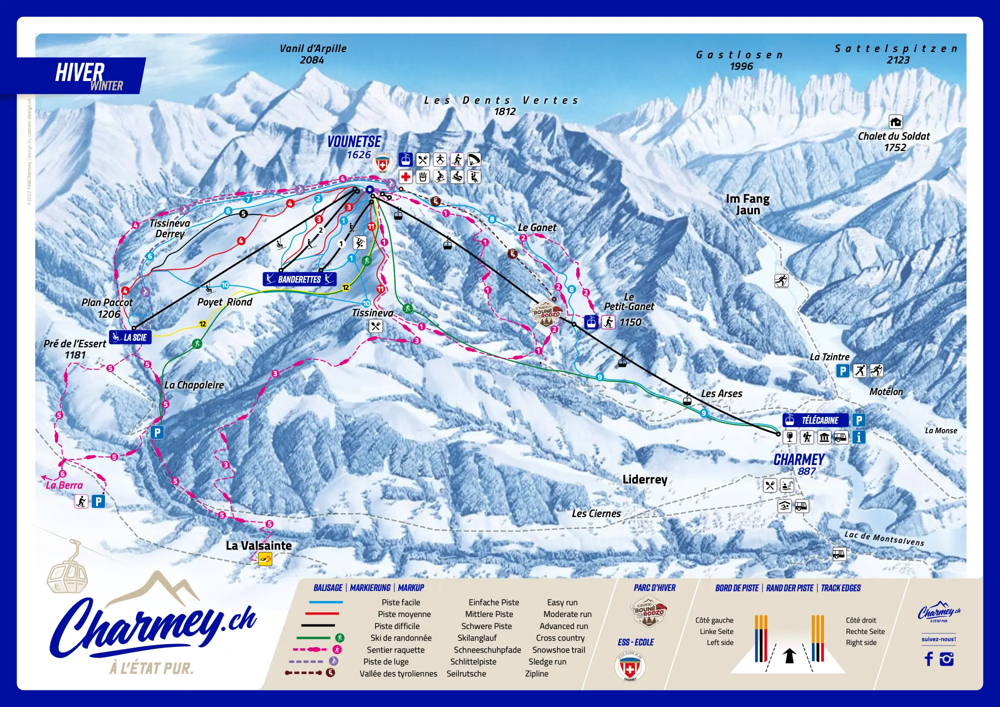
How steep the pistes in Charmey are
Blue: steeper than most.
| Colour | Pistes | Steepest 100 m, typically | All of Switzerland | Here |
|---|---|---|---|---|
| Blue | 3 · 4.5 km | 36 % | 28 % | steeper than most |
| Red | 2 · 3.7 km | 43 % | 38 % | — |
| Black | 1 · 1.3 km | 56 % | 51 % | — |
How this was measured
Skiboard measured the 6 pistes OpenStreetMap maps in Charmey (9.6 km) on swisstopo’s terrain model: the steepest 100 m of each, against every Swiss piste of the same colour.
Measured along the line OpenStreetMap draws, on terrain without snow: snow and grooming soften steps, and a piste can run beside its line. A gradient of 100 % is 45°. Colours as OpenStreetMap maps them, which can differ from the lift company’s piste map: check it before you go.
Piste lines from OpenStreetMap, read 30 Oct 2026 (© OpenStreetMap contributors, ODbL); terrain: swissALTI3D © swisstopo. A piste wrong or missing? Fix the map
Mountain restaurants in Charmey
OpenStreetMap maps one place to eat or drink up the mountain in Charmey.
- Restaurant Le Vounetz Restaurant · about 1'590 m · Map
Opening times change with the season and the snow: check with the restaurant or the lift company before you go.
From OpenStreetMap, read 25 Oct 2026 (© OpenStreetMap contributors, ODbL). A place missing or closed? Fix the map
About Charmey
Ski areas near Charmey
Charmey in numbers
31 % second homes
Hotels, homes and lifts in Val-de-Charmey, where the area’s lifts start: the federal statistics, and what the lift company publishes.
Hotels
The Federal Statistical Office publishes no hotel figures for Val-de-Charmey: it leaves out communes with few hotels.
Homes
31 % of the 1'832 homes in Val-de-Charmey are second homes (housing inventory, October 2026). Above 20 %, the Second Homes Act allows no new second homes there, with narrow exceptions.
Lifts
2 installations with a federal licence (gondolas, cable cars, chairlifts and funiculars; drag lifts are licensed by the cantons). The newest licence: 2011 (La Scie - Vounetse); half of them date from 1998 or earlier.
The 2 federally licensed installations
| Installation | Type | Licensed | Length | Rise | Operator |
|---|---|---|---|---|---|
| La Scie - Vounetse | chairlift | 2011 | – | – | TéléCharmey SA |
| Charmey - Vounetz | gondola | 1998 | 3'146 m | 742 m | TéléCharmey SA |
Commune figures count every hotel guest, not only skiers, and holiday flats are not in the hotel statistics. A licence year is when the installation’s current federal licence starts: usually the year it opened, sometimes a renewal.
Sources: Federal Office for Spatial Development, housing inventory · Federal Office of Transport, cable cars with a federal licence
Featured in
Catalog facts from OpenSkiMap / OpenStreetMap (ODbL). Where an SLF station is nearby, the app shows its measured snow, and the day-pass price is read from the operator’s own shop or tariff; for opening status, check the operator.
Skigebiet Charmey · Domaine skiable Charmey · Comprensorio sciistico Charmey