Brüsti – Attinghausen
Brüsti – Attinghausen is a local ski area in Uri with 2 km of mapped pistes and 5 lifts, between 1'426 m and 1'600 m. Mostly blue, no black. Nearby: Attinghausen.
Rank Brüsti – Attinghausen against every ski area near Lucerne for this weekend
This weekend
Measured snow, weekend forecast and day pass
Snow at the nearest SLF station
There is no SLF snow station within 15 km of Brüsti – Attinghausen at a comparable elevation (within 500 m of the ski area's mid-mountain), so Skiboard shows no measured snow for this ski area.
Weekend forecast
- : Partly cloudy, 5°C, wind 5 km/h
- : Partly cloudy, 5°C, wind 5 km/h
Source: MeteoSwiss, local forecast for Kröntenhütte SAC (1'903 m, 5.5 km from the ski area), with the temperature at the ski area's mid-mountain, averaged over 09:00–16:00. Fetched .
Adult day pass
CHF 32 for . The operator’s published tariff for the season. The coming weekend has no price yet, so this is the day pass for a Saturday in January.
Source: xn--brsti-surenenpass-32b.ch, “Preise Skilift inkl. Seilbahn Attinghausen-Brüsti, Tageskarte Erwachsene”, read .
For the size: the area maps 2 km of pistes and 174 m of vertical, and areas like that charged about CHF 26 for . This pass is 21% more.
Skiboard’s comparison, a curve through the 141 day passes it read for that day; the km are what OpenStreetMap maps, which an operator’s own total can exceed. It says nothing about which lifts run on the day.
Day-pass prices this weekend at every Swiss ski area
Written into this page when it was last built. The live ranking uses the newest values.
Your trip
Travel time from Swiss cities
| From | Car | Train |
|---|---|---|
| Lucerne | 40 min | 1h 10Attinghausen, Seilbahn · 1 change |
| Zug | 45 min | 55 minAttinghausen, Seilbahn · 1 change |
| Zürich | 1h 09 | 1h 24Attinghausen, Seilbahn · 1 change |
| Zurich Airport | 1h 17 | 1h 40Attinghausen, Seilbahn · 2 changes |
| Chur | 1h 20 | 2h 51Attinghausen, Seilbahn · 3 changes |
| Winterthur | 1h 24 | 1h 51Attinghausen, Seilbahn · 2 changes |
| St. Gallen | 1h 38 | 2h 24Attinghausen, Seilbahn · 2 changes |
| Bern | 1h 39 | 2h 25Attinghausen, Seilbahn · 3 changes |
| Basel | 2h 02 | 2h 22Attinghausen, Seilbahn · 2 changes |
| Lausanne | 2h 48 | 3h 45Attinghausen, Seilbahn · 3 changes |
| Geneva | 3h 17 | 4h 24Attinghausen, Seilbahn · 3 changes |
| Geneva Airport | 3h 19 | 4h 17Attinghausen, Seilbahn · 2 changes |
Train: the timetable’s fastest connection leaving the city’s station between 06:30 and 09:30 on Sat 16 Jan 2027, to the valley station of the area’s lowest lift, with the walk from the last stop. Car: an estimate from coordinates, not live traffic. Check your trip on sbb.ch before you go.
Plan your trip
Practical links for the trip. They do not affect the ranking.
- Stay in Attinghausen Booking.com · Saturday to Sunday, 7 Nov – 8 Nov · 2 adults
The mountain
Facts
- Mapped pistes
- 2 km
- Blue pistes
- 2 km
- Red pistes
- <1 km
- Lifts
- 5
- Top station
- 1'600 m
- Base
- 1'426 m
- Vertical
- 174 m
- Longest mapped run
- 0.6 km, from 1'600 m down to 1'427 m
- Mountain restaurants
- 2
- Canton
- Uri
Piste map
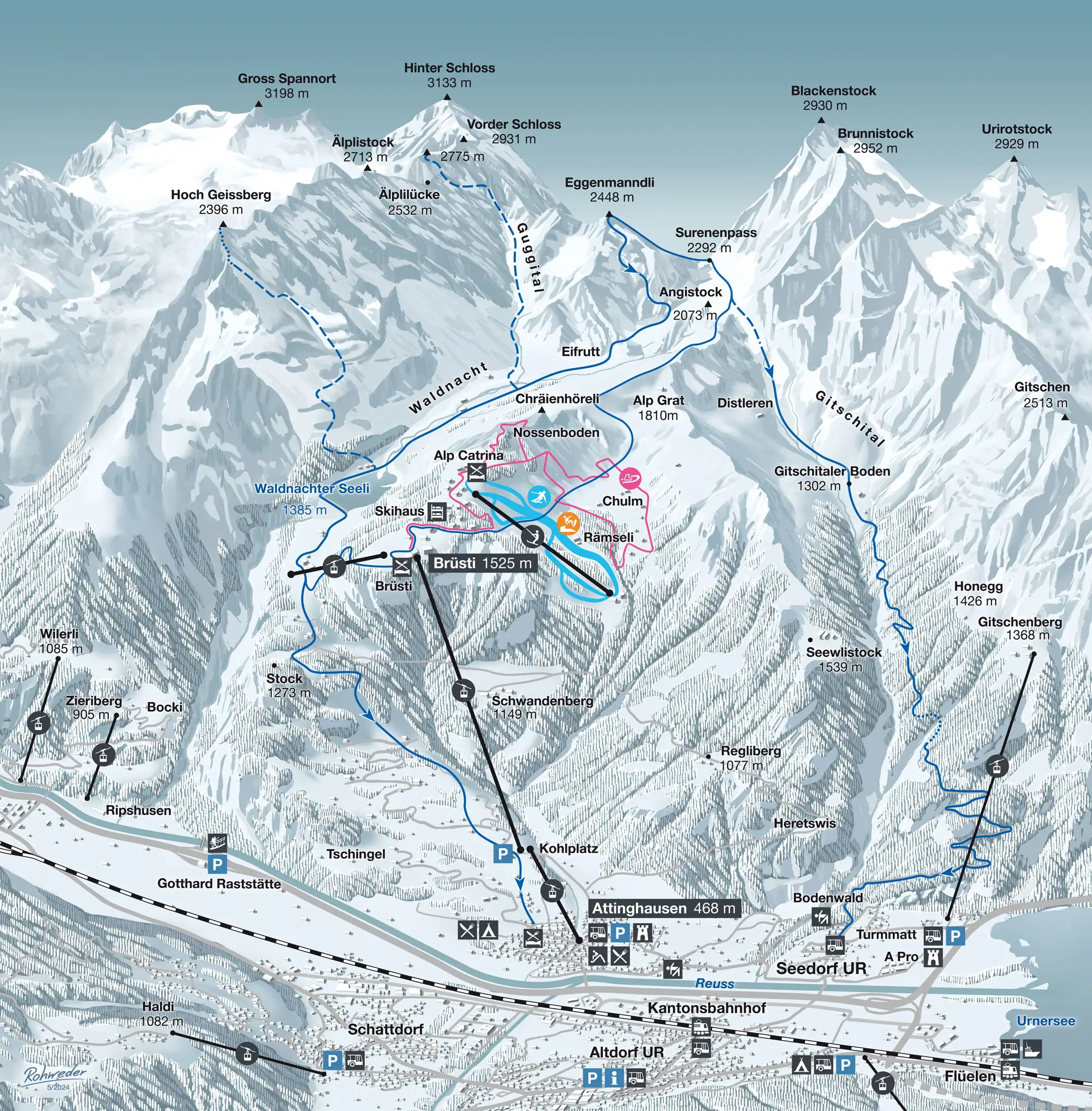
How steep the pistes in Brüsti – Attinghausen are
| Colour | Pistes | Steepest 100 m, typically | All of Switzerland | Here |
|---|---|---|---|---|
| Blue | 2 · 1.6 km | 28 % | 28 % | — |
| Red | 1 · 0.4 km | 41 % | 38 % | — |
How this was measured
Skiboard measured the 3 pistes OpenStreetMap maps in Brüsti – Attinghausen (2.0 km) on swisstopo’s terrain model: the steepest 100 m of each, against every Swiss piste of the same colour.
Measured along the line OpenStreetMap draws, on terrain without snow: snow and grooming soften steps, and a piste can run beside its line. A gradient of 100 % is 45°. Colours as OpenStreetMap maps them, which can differ from the lift company’s piste map: check it before you go.
Piste lines from OpenStreetMap, read 30 Oct 2026 (© OpenStreetMap contributors, ODbL); terrain: swissALTI3D © swisstopo. A piste wrong or missing? Fix the map
Mountain restaurants in Brüsti – Attinghausen
OpenStreetMap maps 2 places to eat or drink up the mountain in Brüsti – Attinghausen, highest first.
- Alp Catrina Restaurant · about 1'590 m · Map
- Berggasthaus Brüsti Restaurant · about 1'530 m · Map
Opening times change with the season and the snow: check with the restaurant or the lift company before you go.
From OpenStreetMap, read 25 Oct 2026 (© OpenStreetMap contributors, ODbL). A place missing or closed? Fix the map
About Brüsti – Attinghausen
Ski areas near Brüsti – Attinghausen
Brüsti – Attinghausen in numbers
19 % second homes
Hotels, homes and lifts in Attinghausen, where the area’s lifts start: the federal statistics, and what the lift company publishes.
Hotels
The Federal Statistical Office publishes no hotel figures for Attinghausen: it leaves out communes with few hotels.
Homes
19 % of the 869 homes in Attinghausen are second homes (housing inventory, October 2026). Below 20 %, the Second Homes Act does not restrict new ones.
Commune figures count every hotel guest, not only skiers, and holiday flats are not in the hotel statistics. A licence year is when the installation’s current federal licence starts: usually the year it opened, sometimes a renewal.
Sources: Federal Office for Spatial Development, housing inventory
Featured in
Catalog facts from OpenSkiMap / OpenStreetMap (ODbL). Where an SLF station is nearby, the app shows its measured snow, and the day-pass price is read from the operator’s own shop or tariff; for opening status, check the operator.
Skigebiet Brüsti – Attinghausen · Domaine skiable Brüsti – Attinghausen · Comprensorio sciistico Brüsti – Attinghausen