Avoriaz
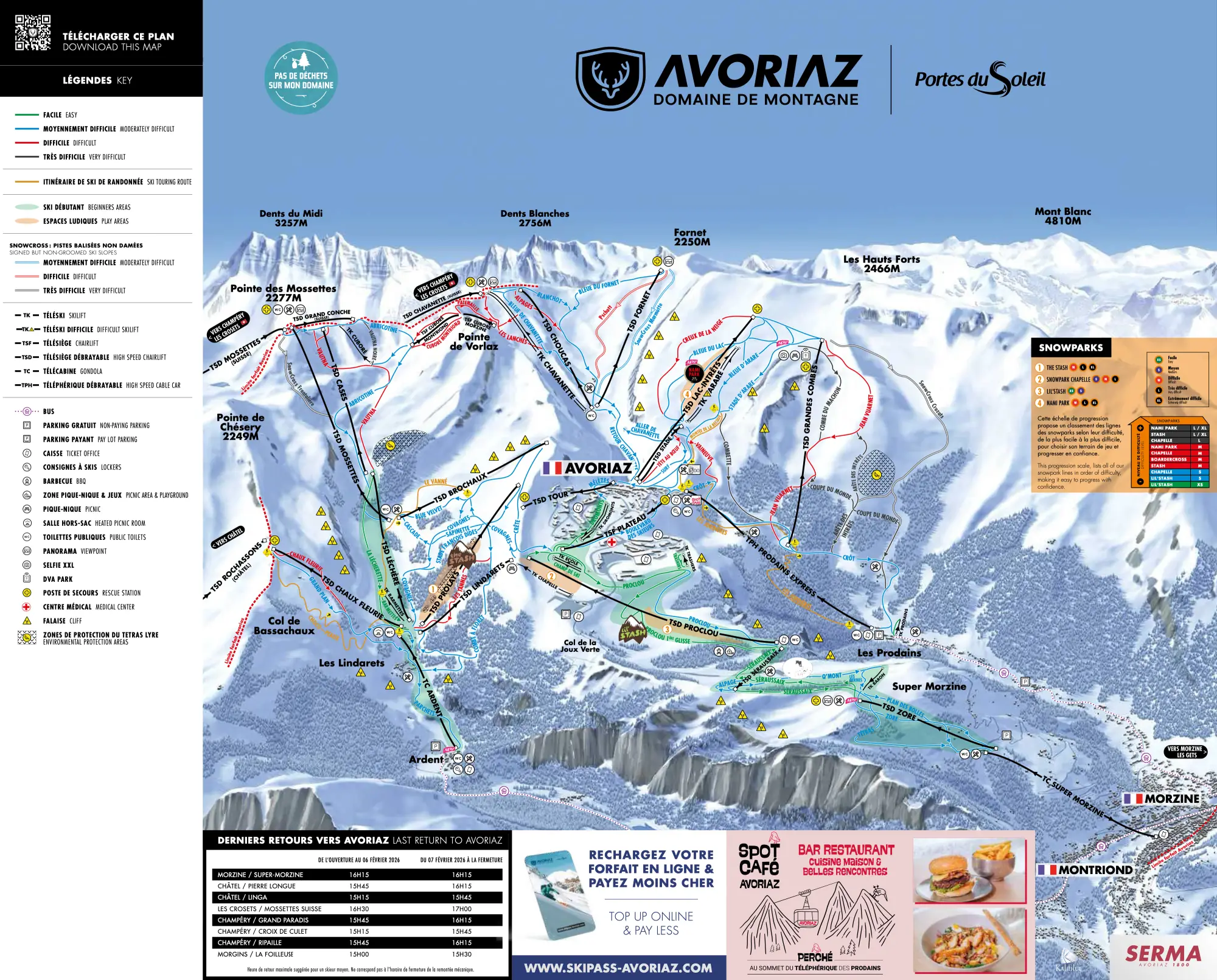
Avoriaz is a ski destination in Valais with 81 km of mapped pistes and 40 lifts, between 1'156 m and 2'250 m. Mostly blue, 3 km black. Nearby: Champéry, Châtel, Les Cretes, Montriond, Morzine.
Rank Avoriaz against every ski area near Lausanne for this weekend
This weekend
Measured snow and weekend forecast
Snow at the nearest SLF station
Snow depth 1 cm, no new snow in 24 hours, at SLF station Les Collines (2'022 m), 2.4 km from the ski area. Measured on .
Source: WSL Institute for Snow and Avalanche Research SLF, IMIS station ILI2. This is the nearest comparable station, not the ski area's own pistes. Fetched .
Weekend forecast
- : Partly cloudy, 4°C, wind 5 km/h
- : Partly cloudy, 4°C, wind 5 km/h
Source: MeteoSwiss, local forecast for Les Crosets (1'665 m, 3.2 km from the ski area), with the temperature at the ski area's mid-mountain, averaged over 09:00–16:00. Fetched .
Written into this page when it was last built. The live ranking uses the newest values.
Your trip
Travel time from Swiss cities
| From | Car | Train |
|---|---|---|
| Lausanne | 47 min | 1h 33estimate |
| Geneva | 59 min | 1h 49estimate |
| Geneva Airport | 1h 02 | 1h 53estimate |
| Bern | 1h 49 | 2h 54estimate |
| Lucerne | 2h 43 | 4h 04estimate |
| Basel | 2h 58 | 4h 23estimate |
| Zürich | 3h 05 | 4h 33estimate |
| Zug | 3h 05 | 4h 33estimate |
| Zurich Airport | 3h 11 | 4h 40estimate |
| Winterthur | 3h 23 | 4h 56estimate |
| Chur | 3h 37 | 5h 14estimate |
| St. Gallen | 3h 54 | 5h 36estimate |
Train: the timetable’s fastest connection leaving the city’s station between 06:30 and 09:30 on Sat 16 Jan 2027, to the valley station of the area’s lowest lift, with the walk from the last stop. Car: an estimate from coordinates, not live traffic. Check your trip on sbb.ch before you go.
Plan your trip
Practical links for the trip. They do not affect the ranking.
- Stay in Avoriaz Booking.com · Saturday to Sunday, 7 Nov – 8 Nov · 2 adults
The mountain
Facts
- Mapped pistes
- 81 km
- Blue pistes
- 63 km
- Red pistes
- 12 km
- Black pistes
- 3 km
- Lifts
- 40
- Top station
- 2'250 m
- Base
- 1'156 m
- Vertical
- 1'094 m
- Longest mapped run
- 6.1 km, from 2'201 m down to 1'209 m
- Mountain restaurants
- 52
- Canton
- Valais
Piste map
How steep the pistes in Avoriaz are
Red: typical.
| Colour | Pistes | Steepest 100 m, typically | All of Switzerland | Here |
|---|---|---|---|---|
| Blue | 1 · 0.5 km | 28 % | 28 % | — |
| Red | 4 · 2.1 km | 41 % | 38 % | typical |
The steepest 100 m: 57 % on Cuboré Montriond (red).
How this was measured
Skiboard measured the 5 pistes OpenStreetMap maps in Avoriaz (2.6 km) on swisstopo’s terrain model: the steepest 100 m of each, against every Swiss piste of the same colour. Only the Swiss side: swisstopo’s model stops at the border.
Measured along the line OpenStreetMap draws, on terrain without snow: snow and grooming soften steps, and a piste can run beside its line. A gradient of 100 % is 45°. Colours as OpenStreetMap maps them, which can differ from the lift company’s piste map: check it before you go.
Piste lines from OpenStreetMap, read 30 Oct 2026 (© OpenStreetMap contributors, ODbL); terrain: swissALTI3D © swisstopo. A piste wrong or missing? Fix the map
Mountain restaurants in Avoriaz
OpenStreetMap maps 52 places to eat or drink up the mountain in Avoriaz, highest first.
- cookie.cafe Restaurant · about 2'280 m · Map
- Les Clavets Restaurant · Map
- Lapisa Restaurant · Map
Show 49 more
- Chez Jojo et Jibi Restaurant · Map
- Hotel des Portes du Soliel Restaurant · Map
- O'Padcha Restaurant · about 2'150 m · Map
- Fantaski Restaurant · Map
- L'Etable Restaurant · Map
- La tane o marmottes Restaurant · Map
- Le Bois Prin Restaurant · Map
- Restaurant d'Altitude Chez Crépy Restaurant · Map
- La Brasserie Restaurant · about 1'850 m · Map
- Le Fantastic Restaurant · about 1'850 m · Map
- Why Not Restaurant · about 1'830 m · Map
- The Place Bar · about 1'830 m · Map
- Shooters Restaurant · about 1'830 m · Map
- La Sucrerie Restaurant · about 1'800 m · Map
- Igloo village Bar · about 1'800 m · Map
- Mountain Piz'Burg Restaurant · about 1'800 m · Map
- Globe Trotter's Café · about 1'800 m · Map
- La Boule de Neige Restaurant · about 1'800 m · Map
- Restaurant de Montagne Restaurant · about 1'800 m · Map
- Snack Kebab Burger Restaurant · about 1'800 m · Map
- La Poya Restaurant · about 1'770 m · Map
- La Cachette Bar · about 1'770 m · Map
- Changabang Snack bar · about 1'770 m · Map
- Les Trappeurs Restaurant · about 1'770 m · Map
- Le Télébenne Snack bar · about 1'750 m · Map
- Chez Flo Restaurant · about 1'740 m · Map
- Les Crêtes de Zore Restaurant · about 1'740 m · Map
- L'Abricotine Restaurant · about 1'600 m · Map
- Refuge de l'Abricotine Mountain hut · about 1'600 m · Map
- Les Alpages sur les pistes Café · about 1'510 m · Map
- Les Portes du Soleil Restaurant · about 1'500 m · Map
- La Passe Montagne Restaurant · about 1'500 m · Map
- La Pomme de Pin Restaurant · about 1'500 m · Map
- Mamo's Café Café · about 1'500 m · Map
- Les Marmottes Restaurant · about 1'500 m · Map
- Les Barmettes Café · about 1'500 m · Map
- La grenouille du marais Restaurant · about 1'470 m · Map
- La Ferme Restaurant · about 1'460 m · Map
- Le Chaudron Restaurant · about 1'460 m · Map
- La Crémaillère Restaurant · about 1'460 m · Map
- Le Petit Lindaret Restaurant · about 1'460 m · Map
- La Terrasse Restaurant · about 1'460 m · Map
- La T’chapa Restaurant · about 1'460 m · Map
- L'passage Restaurant · about 1'450 m · Map
- Ler’Noyon Restaurant · about 1'450 m · Map
- Les Clarines Restaurant · about 1'450 m · Map
- Buvette de Montagne «Sur les Côtes» Restaurant · Map
- Happy Hours Bar · about 1'210 m · Map
- Le Câble Restaurant · about 1'170 m · Map
Opening times change with the season and the snow: check with the restaurant or the lift company before you go.
From OpenStreetMap, read 25 Oct 2026 (© OpenStreetMap contributors, ODbL). A place missing or closed? Fix the map
About Avoriaz
Ski areas near Avoriaz
How popular Avoriaz is
Condé Nast Traveller Readers’ Choice Awards 2026: 20th among the ski resorts of Europe (82.14 of 100)
What polls say
- Condé Nast Traveller Readers’ Choice Awards 2026: 20th among the ski resorts of Europe (82.14 of 100). Readers of the British travel magazine voted; it doesn’t say how many.
Skiboard adds no score of its own: the counts are what Seilbahnen Schweiz and the lift companies publish, the placings are polls run by others. Searches and social-media posts follow the news more than skiers, so they are left out.
Featured in
Catalog facts from OpenSkiMap / OpenStreetMap (ODbL). Where an SLF station is nearby, the app shows its measured snow, and the day-pass price is read from the operator’s own shop or tariff; for opening status, check the operator.
Skigebiet Avoriaz · Domaine skiable Avoriaz · Comprensorio sciistico Avoriaz