Les Portes du Soleil
Les Portes du Soleil is a ski destination in Valais with 409 km of mapped pistes and 194 lifts, between 920 m and 2'250 m. Mostly blue and red, 22 km black. Nearby: Abondance, Bellevaux, Champoussin, Champéry, Châtel.
Rank Les Portes du Soleil against every ski area near Lausanne for this weekend
This weekend
Measured snow, weekend forecast and day pass
Snow at the nearest SLF station
Snow depth 1 cm, no new snow in 24 hours, at SLF station Les Collines (2'022 m), 6.4 km from the ski area. Measured on .
Source: WSL Institute for Snow and Avalanche Research SLF, IMIS station ILI2. This is the nearest comparable station, not the ski area's own pistes. Fetched .
Weekend forecast
- : Partly cloudy, 5°C, wind 5 km/h
- : Partly cloudy, 5°C, wind 5 km/h
Source: MeteoSwiss, local forecast for Les Crosets (1'665 m, 7.4 km from the ski area), with the temperature at the ski area's mid-mountain, averaged over 09:00–16:00. Fetched .
Adult day pass
CHF 75 for . The operator’s published tariff for the season. The coming weekend has no price yet, so this is the day pass for a Saturday in January.
Source: shop.skipass-pds-ch.ch, “1 Jour Portes du Soleil, Adulte”, read .
Day-pass prices this weekend at every Swiss ski area
Written into this page when it was last built. The live ranking uses the newest values.
Your trip
Parking at Les Portes du Soleil
Main car park: Parking du Grand Paradis, Champéry · free · regiondentsdumidi.ch, read 30 Oct 2026
6 car parks by the lifts
OpenStreetMap maps these 6 car parks by the lifts of Les Portes du Soleil, the biggest first.
- Parking du Grand Paradis Car park · 800 spaces · free · by the Grand Paradis · by a piste · Map
- Underground car park paid · by the Crosets · by a piste · Map
- Parking du Téléphérique Car park · paid · 70 m from the Champéry - Croix de Culet · Map
- Car park free · 40 m from the Djeu des Têtes · by a piste · Map
- Car park free · 70 m from the Géant · piste 70 m away · Map
- Car park paid · 70 m from the Morgins-Foilleuse · by a piste · Map
Distances are in a straight line to the bottom station of the nearest lift. Fees change: check with the car park before you go.
Car parks from OpenStreetMap, read 30 Oct 2026 (© OpenStreetMap contributors, ODbL). A car park missing? Fix the map
Travel time from Swiss cities
| From | Car | Train |
|---|---|---|
| Lausanne | 43 min | 1h 40Champéry · 1 change |
| Geneva | 57 min | 2h 32Champéry · 1 change |
| Geneva Airport | 1h 00 | 2h 40Champéry · 1 change |
| Bern | 1h 46 | 3h 02Champéry · 2 changes |
| Lucerne | 2h 43 | 4h 35Morgins, poste · 5 changes |
| Basel | 2h 54 | 4h 08Morgins, poste · 3 changes |
| Zürich | 3h 03 | 4h 02Morgins, poste · 4 changes |
| Zug | 3h 04 | 4h 39Morgins, poste · 4 changes |
| Zurich Airport | 3h 09 | 4h 25Morgins, poste · 4 changes |
| Winterthur | 3h 21 | 4h 32Morgins, poste · 4 changes |
| Chur | 3h 38 | 5h 32Morgins, poste · 4 changes |
| St. Gallen | 3h 54 | 5h 11Morgins, poste · 5 changes |
Train: the timetable’s fastest connection leaving the city’s station between 06:30 and 09:30 on Sat 16 Jan 2027, to the valley station of the area’s lowest lift, with the walk from the last stop. Car: an estimate from coordinates, not live traffic. Check your trip on sbb.ch before you go.
Plan your trip
Practical links for the trip. They do not affect the ranking.
- Stay in Les Portes du Soleil Booking.com · Saturday to Sunday, 7 Nov – 8 Nov · 2 adults
The mountain
Facts
- Mapped pistes
- 409 km
- Blue pistes
- 243 km
- Red pistes
- 135 km
- Black pistes
- 22 km
- Ski routes
- <1 km
- Lifts
- 194
- Top station
- 2'250 m
- Base
- 920 m
- Vertical
- 1'330 m
- Longest mapped run
- 8.4 km, from 2'249 m down to 1'311 m
- Advertised longest run
- 10 km, Ripaille – Grand-Paradis
- Mountain restaurants
- 138
- Canton
- Valais
Piste map
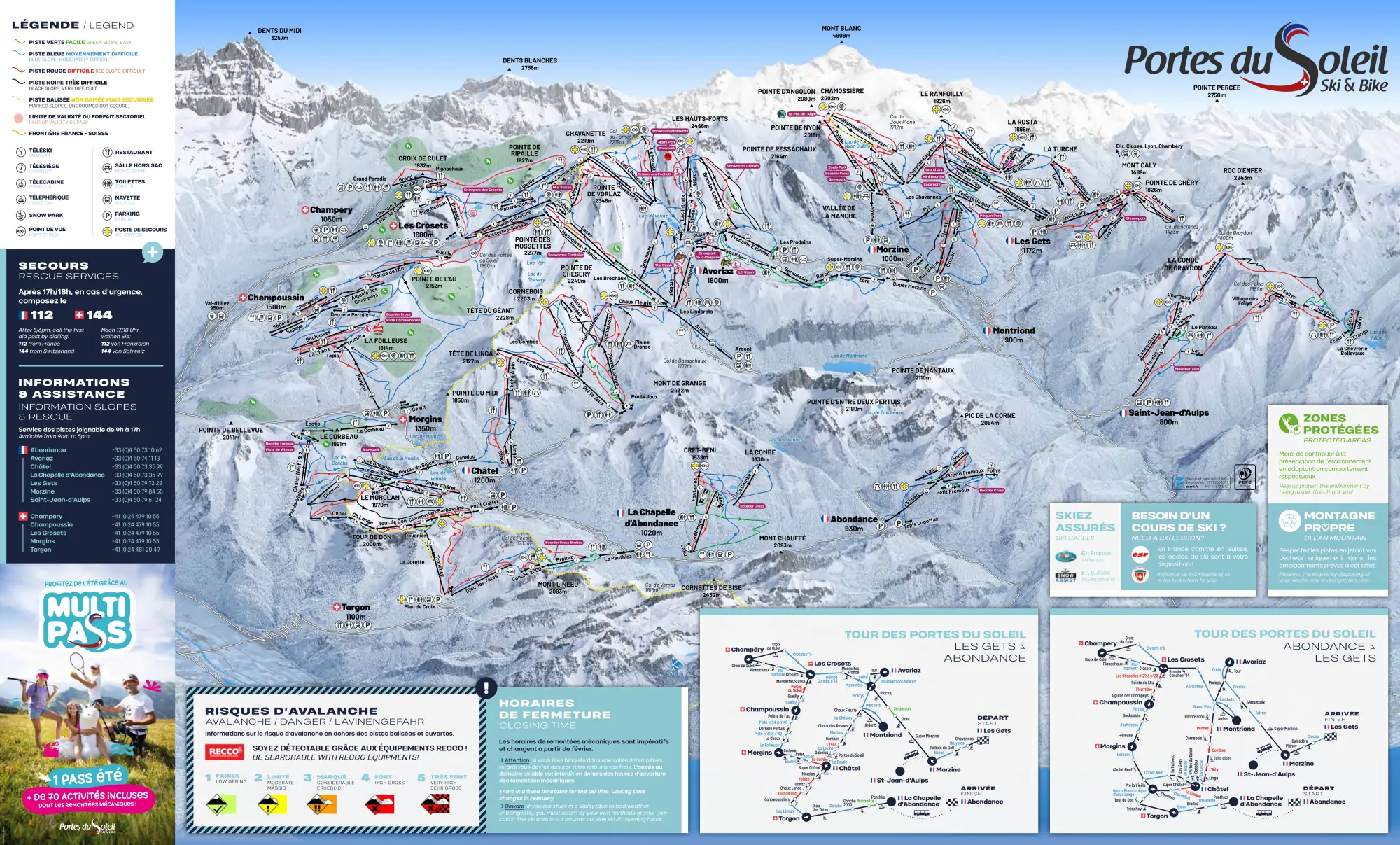
How steep the pistes in Les Portes du Soleil are
Blue: typical. Red and black: steeper than most.
| Colour | Pistes | Steepest 100 m, typically | All of Switzerland | Here |
|---|---|---|---|---|
| Blue | 58 · 65.8 km | 28 % | 28 % | typical |
| Red | 35 · 38.2 km | 44 % | 38 % | steeper than most |
| Black | 8 · 6.9 km | 55 % | 51 % | steeper than most |
The steepest 100 m: 68 % on 15 Grand Conche (black).
Flat stretches 1
- Planachaux Blue · 33 % of its 660 m nearly flat: on a snowboard you may have to push · Map
Long descents without flat stretches 3
How this was measured
Skiboard measured the 101 pistes OpenStreetMap maps in Les Portes du Soleil (110.9 km) on swisstopo’s terrain model: the steepest 100 m of each, against every Swiss piste of the same colour. Only the Swiss side: swisstopo’s model stops at the border.
Measured along the line OpenStreetMap draws, on terrain without snow: snow and grooming soften steps, and a piste can run beside its line. A gradient of 100 % is 45°. Colours as OpenStreetMap maps them, which can differ from the lift company’s piste map: check it before you go.
Piste lines from OpenStreetMap, read 30 Oct 2026 (© OpenStreetMap contributors, ODbL); terrain: swissALTI3D © swisstopo. A piste wrong or missing? Fix the map
Mountain restaurants in Les Portes du Soleil
OpenStreetMap maps 138 places to eat or drink up the mountain in Les Portes du Soleil, highest first.
- cookie.cafe Restaurant · about 2'280 m · Map
- O'Padcha Restaurant · about 2'150 m · Map
- Refuge de Chésery Restaurant · Map
Show 135 more
- Le Relais Restaurant · Map
- La Croix de Culet Restaurant · about 1'930 m · Map
- Chez Jojo et Jibi Restaurant · about 1'920 m · Map
- Lapisa Restaurant · Map
- Les Clavets Restaurant · Map
- Cantine de They Restaurant · Map
- Le Chaudron Restaurant · Map
- La Brasserie Restaurant · about 1'850 m · Map
- Le Fantastic Restaurant · about 1'850 m · Map
- La Foilleuse Restaurant · about 1'850 m · Map
- Coquoz Restaurant · about 1'840 m · Map
- Why Not Restaurant · about 1'830 m · Map
- The Place Bar · about 1'830 m · Map
- Shooters Restaurant · about 1'830 m · Map
- Marcheuson Restaurant · about 1'820 m · Map
- La Foilleuse Restaurant · about 1'820 m · Map
- La Sucrerie Restaurant · about 1'800 m · Map
- Igloo village Bar · about 1'800 m · Map
- Mountain Piz'Burg Restaurant · about 1'800 m · Map
- Globe Trotter's Café · about 1'800 m · Map
- La Boule de Neige Restaurant · about 1'800 m · Map
- Restaurant de Montagne Restaurant · about 1'800 m · Map
- Snack Kebab Burger Restaurant · about 1'800 m · Map
- Les Aiguillettes Restaurant · about 1'800 m · Map
- La Poya Restaurant · about 1'770 m · Map
- La Cachette Bar · about 1'770 m · Map
- Changabang Snack bar · about 1'770 m · Map
- Les Trappeurs Restaurant · about 1'770 m · Map
- Le Télébenne Snack bar · about 1'750 m · Map
- Chez Flo Restaurant · about 1'740 m · Map
- Les Crêtes de Zore Restaurant · about 1'740 m · Map
- La Grande Ourse Restaurant · about 1'740 m · Map
- Bochasses Restaurant · about 1'730 m · Map
- La Ferme des Pistes Restaurant · about 1'700 m · Map
- Chalet Neuf Restaurant · about 1'690 m · Map
- Hotel des Portes du Soliel Restaurant · about 1'690 m · Map
- La Crêperie Des Crosets Café · about 1'670 m · Map
- La Cabushe Restaurant · about 1'670 m · Map
- Sundance Bar/Restaurant Restaurant · about 1'660 m · Map
- La Rosset'taz Restaurant · Map
- Le Mouflon Restaurant · about 1'660 m · Map
- Les Lhottys Restaurant · about 1'660 m · Map
- Bienview a la leiche Restaurant · about 1'660 m · Map
- Chez Nelly Restaurant · about 1'660 m · Map
- La Bourri Restaurant · about 1'650 m · Map
- Le Corbeau Restaurant · about 1'650 m · Map
- Wetzet Restaurant · about 1'650 m · Map
- La tane o marmottes Restaurant · about 1'640 m · Map
- Le Refuge Restaurant · about 1'640 m · Map
- Restaurant d'Altitude Chez Crépy Restaurant · about 1'640 m · Map
- L'Etable Restaurant · about 1'640 m · Map
- Le Bois Prin Restaurant · about 1'640 m · Map
- Fantaski Restaurant · about 1'630 m · Map
- Terrasse de Morclan Restaurant · about 1'620 m · Map
- L'escale Restaurant · about 1'620 m · Map
- L'Abricotine Restaurant · about 1'600 m · Map
- Refuge de l'Abricotine Mountain hut · about 1'600 m · Map
- Le Vaffieu Restaurant · about 1'540 m · Map
- U Yeu tsalé Restaurant · about 1'540 m · Map
- Chez Nannon Restaurant · about 1'530 m · Map
- Le Belvédère Restaurant · about 1'530 m · Map
- Les Alpages sur les pistes Café · about 1'510 m · Map
- L'Escale Blanche Restaurant · about 1'510 m · Map
- La Licorne Restaurant · about 1'510 m · Map
- Les Portes du Soleil Restaurant · about 1'500 m · Map
- Chalet de Nabor Restaurant · about 1'500 m · Map
- La Passe Montagne Restaurant · about 1'500 m · Map
- La Pomme de Pin Restaurant · about 1'500 m · Map
- Mamo's Café Café · about 1'500 m · Map
- Les Marmottes Restaurant · about 1'500 m · Map
- Les Barmettes Café · about 1'500 m · Map
- Le Grand Cry Restaurant · about 1'490 m · Map
- Chez Etienne Restaurant · about 1'490 m · Map
- Le Yeti Snack bar · about 1'480 m · Map
- La Croix Blanche Restaurant · about 1'480 m · Map
- Telebar du Mont Blanc Café · about 1'470 m · Map
- La Petite Ourse Restaurant · about 1'470 m · Map
- La grenouille du marais Restaurant · about 1'470 m · Map
- La Ferme Restaurant · about 1'460 m · Map
- Le Mousseron Restaurant · about 1'460 m · Map
- Le Chaudron Restaurant · about 1'460 m · Map
- La Crémaillère Restaurant · about 1'460 m · Map
- Le Petit Lindaret Restaurant · about 1'460 m · Map
- La Terrasse Restaurant · about 1'460 m · Map
- La T’chapa Restaurant · about 1'460 m · Map
- L'passage Restaurant · about 1'450 m · Map
- Ler’Noyon Restaurant · about 1'450 m · Map
- Les Clarines Restaurant · about 1'450 m · Map
- La Pointe de Nyon Restaurant · about 1'420 m · Map
- La Païka Restaurant · about 1'420 m · Map
- Chanterelle Restaurant · about 1'420 m · Map
- Encrenaz Bar Restaurant · about 1'410 m · Map
- Le Chalet du Golf Restaurant · Map
- Le Chasse Montagne Restaurant · about 1'360 m · Map
- Le Crêt Restaurant · about 1'360 m · Map
- Le Tseudron Restaurant · about 1'340 m · Map
- Le Grand Pré Restaurant · about 1'320 m · Map
- Les 2 Criquets Restaurant · about 1'320 m · Map
- L'Abreuvoir Restaurant · Map
- Le Crêt Béni Restaurant · about 1'300 m · Map
- La Perdrix Blanche Restaurant · about 1'300 m · Map
- Buvette de Montagne «Sur les Côtes» Restaurant · Map
- Les Mouilles Restaurant · about 1'290 m · Map
- Le Monchu Restaurant · about 1'290 m · Map
- La grenouille Snack bar · about 1'290 m · Map
- La Roulotte Snack bar · about 1'250 m · Map
- Restaurant du Lac Restaurant · about 1'250 m · Map
- Chez Séverine Snack bar · about 1'240 m · Map
- Le Roitelet Restaurant · Map
- Le QG Restaurant · about 1'230 m · Map
- La Grande Lanière Restaurant · about 1'210 m · Map
- Happy Hours Bar · about 1'210 m · Map
- Folies Indiennes Restaurant · about 1'170 m · Map
- La Bokka Restaurant · about 1'170 m · Map
- Vina Annapurna Restaurant · about 1'170 m · Map
- Le Câble Restaurant · about 1'170 m · Map
- Claudie Creperie Restaurant · about 1'170 m · Map
- Gets Pizza Restaurant · about 1'170 m · Map
- Ice-Burg Restaurant · about 1'170 m · Map
- L'Aprèski Bar Resto Restaurant · about 1'170 m · Map
- La R'Mize Restaurant · about 1'170 m · Map
- Notes Gourmandes Restaurant · about 1'170 m · Map
- 412 Corner Snack bar · about 1'170 m · Map
- Velvette Restaurant · about 1'170 m · Map
- Baboushka Restaurant · about 1'160 m · Map
- Crêperie Mémé Confiture Restaurant · about 1'160 m · Map
- hop. MICRO-PUB, MAXI CRAFT Bar · about 1'160 m · Map
- Jeux Trinque Bar · about 1'160 m · Map
- La Part des Anges Restaurant · about 1'160 m · Map
- La Pela by Camille Restaurant · about 1'160 m · Map
- Ô Chalet Restaurant · about 1'160 m · Map
- Primo Restaurant · about 1'160 m · Map
- Sush'ski Restaurant · about 1'160 m · Map
- Le Grand Rocher Restaurant · about 1'160 m · Map
- La R'mize Restaurant · about 1'120 m · Map
Opening times change with the season and the snow: check with the restaurant or the lift company before you go.
From OpenStreetMap, read 25 Oct 2026 (© OpenStreetMap contributors, ODbL). A place missing or closed? Fix the map
About Les Portes du Soleil
Ski areas near Les Portes du Soleil
Les Portes du Soleil in numbers
43'326 winter hotel nights · 37 % second homes
Hotels, homes and lifts in Val-d'Illiez, Troistorrents, Champéry, Collombey-Muraz and Vionnaz, where the area’s lifts start: the federal statistics, and what the lift company publishes.
Hotels
In winter 2025/26 (November to April) the hotels of Champéry sold 43'326 overnight stays, +13.6 % on 2024/25. 49 % of their rooms were occupied, with up to 696 beds in 12 open hotels. In summer 2025 (May to October) they sold 32'905; over winter 2024/25 and that summer, 54 % of the nights were in winter.
Guests in winter 2025/26: 52 % of the nights were Swiss residents’, then France 16 %, Germany 14 %, Belgium 6 % and United Kingdom 4 %.
Winter hotel nights, season by season
| Winter | Overnight stays | Rooms occupied | Beds at peak |
|---|---|---|---|
| 2025/26 | 43'326 | 49 % | 696 |
| 2024/25 | 38'135 | 43 % | 696 |
| 2023/24 | 37'404 | 43 % | 696 |
| 2022/23 | 37'150 | 46 % | 626 |
| 2021/22 | 35'946 | 43 % | 671 |
| 2020/21 | 18'715 | 28 % | 553 |
| 2019/20 | 31'852 | 47 % | 625 |
| 2018/19 | 35'839 | 43 % | 669 |
| 2017/18 | 39'889 | 45 % | 689 |
| 2016/17 | 32'765 | 41 % | 629 |
Homes
37 % of the 15'276 homes in Val-d'Illiez, Troistorrents, Champéry, Collombey-Muraz and Vionnaz are second homes (housing inventory, October 2026). Above 20 %, the Second Homes Act allows no new second homes there, with narrow exceptions.
Lifts
15 installations with a federal licence (gondolas, cable cars, chairlifts and funiculars; drag lifts are licensed by the cantons). The newest licence: 2023 (Morgins - La Foilleuse); half of them date from 1995 or earlier.
The 15 federally licensed installations
| Installation | Type | Licensed | Length | Rise | Operator |
|---|---|---|---|---|---|
| Morgins - La Foilleuse | gondola | 2023 | 1'372 m | 499 m | Portes du Soleil Suisse SA |
| En l’Au – Pointe de l‘Au | chairlift | 2013 | 965 m | 367 m | Portes du Soleil Suisse SA |
| Bochasse - Derrière Pertuis | chairlift | 2012 | 1'667 m | 379 m | Portes du Soleil Suisse SA |
| Les Crosets - Grande Conche | chairlift | 2011 | – | – | Portes du Soleil Suisse SA |
| Les Crosets - Marcheuson | chairlift | 2008 | 836 m | 253 m | Portes du Soleil Suisse SA |
| Grand Paradis - Planachaux | chairlift | 2004 | 1'629 m | 634 m | Portes du Soleil Suisse SA |
| Planachaux - Croix-de-Culet | chairlift | 2004 | 756 m | 253 m | Portes du Soleil Suisse SA |
| Plan du Croix - Tête du Tronchey | chairlift | 1995 | 1'576 m | 552 m | Télé-Torgon SA |
| Les Crosets - Pointe-de-Mossette | chairlift | 1994 | 1'787 m | 570 m | Portes du Soleil Suisse SA |
| Léchereuse - Pauvre-Conche | chairlift | 1991 | 1'002 m | 305 m | Portes du Soleil Suisse SA |
| Le Segneux - La Foilleuse | chairlift | 1989 | 1'021 m | 316 m | Portes du Soleil Suisse SA |
| Champoussin - Aiguille des Champeys | chairlift | 1988 | 1'025 m | 364 m | Portes du Soleil Suisse SA |
| Champéry - Croix-de-Culet | cable car | 1987 | 2'143 m | 899 m | Portes du Soleil Suisse SA |
| Morgins - Les Têtes (Le Corbeau) | chairlift | 1987 | 1'215 m | 414 m | Portes du Soleil Suisse SA |
| Les Pas - Pas-de-Chavanette | chairlift | 1968 | 898 m | 331 m | Portes du Soleil Suisse SA |
Commune figures count every hotel guest, not only skiers, and holiday flats are not in the hotel statistics. A licence year is when the installation’s current federal licence starts: usually the year it opened, sometimes a renewal.
Sources: Federal Statistical Office, hotel statistics (HESTA) · Federal Office for Spatial Development, housing inventory · Federal Office of Transport, cable cars with a federal licence
Featured in
Catalog facts from OpenSkiMap / OpenStreetMap (ODbL). Where an SLF station is nearby, the app shows its measured snow, and the day-pass price is read from the operator’s own shop or tariff; for opening status, check the operator.
Skigebiet Les Portes du Soleil · Domaine skiable Les Portes du Soleil · Comprensorio sciistico Les Portes du Soleil